Contact Us

is an innovative multi-scale ARR and REDD sustainability screening tool is an innovative multi-scale ARR and REDD sustainability screening tool

They use data analytics and strategic insights to help create sustainable projects that generate high-integrity carbon credits. This is how our team handled the tech part of the project.
  • Portugal

    Country

  • 1 year

    Collaboration duration

  • 5 specialists

    Team

Visit website

What is RAMO: Features & Mission

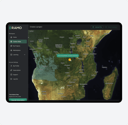
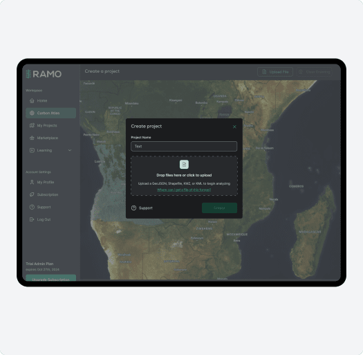
RAMO is a cloud-based platform that is designed to support Nature-Based Solutions (NbS). It empowers organizations, communities, and stakeholders to collaboratively plan, implement, and scale sustainable environmental initiatives.

They integrate advanced technologies like geospatial intelligence, dynamic data analytics, and artificial intelligence to simplify complex systems and accelerate regenerative projects.

RAMO’s mission is to transform fragmented and complex NbS efforts into streamlined, user-friendly solutions that deliver measurable ecological and social benefits.

What is RAMO: Features & Mission

Here are the Key Aspects that Set RAMO Apart:

  • Multi-Scale Suitability Screening Tool

    This tool uses high-resolution datasets, remote sensing, and machine learning to assess carbon credit project opportunities at varying scales — from country-level overviews to detailed hectare-by-hectare analyses. This ensures precision in identifying optimal sites for carbon sequestration projects while aligning with Verra methodologies (VM00047 for ARR and VM00048 for REDD).

  • Dynamic Baselining and Monitoring

    The system incorporates dynamic baselining and continuous monitoring into its project lifecycle. They leverage geospatial intelligence and machine learning to provide real-time validation of carbon sequestration scenarios. This ensures compliance with international standards and enhances transparency.

  • Stakeholder Collaboration

    RAMO prioritizes collaboration with local communities, Indigenous groups, and trusted partners like Earthly and Grounded. This ensures that projects deliver co-benefits such as biodiversity conservation and community development alongside carbon sequestration. Additionally, decentralized models like the Open Forest Protocol (OFP) empower small-to-medium-sized projects by decentralizing verification processes through blockchain technology.

  • High-Integrity Carbon Credits

    Through advanced modeling, rigorous science, and community input, RAMO ensures the generation of high-integrity carbon credits that are verifiable, credible, and aligned with global climate goals.

Here are the Key Aspects that Set RAMO Apart:

Challenges of Development for RAMO

Challenges of Development for RAMO
  • Processing Massive Geospatial Datasets

    Handling large vector and raster files containing dense environmental data (like forest density and soil composition) required custom optimization techniques to ensure efficient processing and visualization.

  • Providing Scalable Data Visualization

    Displaying complex, layered geospatial data across global maps — while keeping performance smooth — was technically demanding, especially when switching between country-level and local territory views.

  • Implementing Strict Data Access Control

    RAMO needed a robust multi-tenant system where each company could only access specific datasets and maps. Ensuring tight admin-level control over who sees what added architectural complexity.

  • Integrating Diverse Technologies Seamlessly

    Combining Azure cloud infrastructure, geospatial mapping via Felt, and AI-driven analytics into a single, user-friendly platform required careful coordination across backend and frontend systems.

Our Contribution

  • Cloud-Based Solutions

    Scalable, secure infrastructure designed for handling large-scale geospatial and ecological datasets. We used Azure cloud services to manage and scale backend processing.

  • Geospatial Mapping & GIS Systems

    Advanced mapping solutions integrating GIS technology for land assessment and carbon credit.

  • Processing Vector and Raster Data

    Our team built a system to process vector and raster geodata to prepare them for visualization on a global map. This data includes high-resolution layers with critical environmental indicators.

  • Frontend Integration with Felt API

    Felt was used as a key tool to visualize this geospatial data on the front end. The system creates separate projects for each region or country, helping stakeholders explore data territory by territory.

  • Strict Data Access Control

    RAMO is designed as a multi-tenant platform, where each company or organization (tenant) only gets access to a limited set of maps and datasets, depending on permissions. The administrator has full control over data sharing and availability, which helps maintain data privacy and integrity.

  • Custom Atlas with Mapbox

    We created a fully customized map interface using Mapbox, complete with a tailored design and a flexible control panel. This setup allows users to overlay Felt projects on top of custom layers, interact with GEO JSON files, draw directly on the map, and even handle massive uploads — including files over 1GB.

  • Stripe Subscription Setup

    Our team integrated Stripe to manage subscription plans, giving RAMO full flexibility to offer tiered access while keeping billing simple and secure.

Our Contribution
How the Platform Works

How the Platform Works

RAMO provides access to companies focused on GIS data — specifically data on forest density, soil, and other geospatial insights. The core goal of the project is to equip these companies with accurate, administrator-controlled access to carbon credit data based on geospatial analysis.

SpdLoad CEO Maksym Babych recently joined the RAMO team as COO. With over 12 years of experience in software development and a strong focus on AI-driven solutions, Maksym brings both technical expertise and a deep commitment to creating positive change. While this is a part-time role, he sees RAMO as a powerful way to help companies reach net zero faster — and with less friction. As he puts it:
RAMO is built to solve a very real challenge: how to scale nature-based solutions without losing scientific integrity or local relevance. In the end, hitting net-zero targets means nothing if the data behind the projects isn’t accurate or transparent. 

That’s where GIS, AI, and remote sensing come in — they help us map land use, predict outcomes, and verify carbon impact with confidence. But what makes RAMO different is how we bring all of that together in one platform that’s actually usable by the people doing the work — on the ground, in the field, and in the boardroom.

Key Features of RAMO

Key Features of RAMO
  • End-to-End Project Support

    RAMO provides services such as baseline determination, carbon accounting, monitoring plan development, and ongoing project tracking using satellite imagery and geospatial data.

  • Carbon Credit Development

    The platform specializes in designing projects that generate high-integrity carbon credits while delivering co-benefits for local communities. It ensures compliance with international standards like Verra and CCB.

  • Geospatial Intelligence

    Offers tools for land scanning, risk assessment (e.g., deforestation risks), and suitability analysis for conservation or reforestation projects.

  • Stakeholder Collaboration

    RAMO engages with Indigenous and Local Community Partners (ILCPs) and rural communities to co-develop NbS projects that align with local needs and global sustainability goals.

  • Educational Resources

    Provides professional development programs such as boot camps on AI in nature-based solutions.

Key Features of RAMO

Related Services

  • Hire AI Developers

    Accelerate AI adoption and enhance productivity with dedicated AI engineers from SpdLoad.

    Learn more
  • SaaS Development

    Become an industry leader with a SaaS solution that is resilient, scalable, and user-friendly.

    Learn more
  • UI/UX Design

    Create a user-oriented desktop and mobile app design for all your business ideas.

    Learn more

Collaboration Summary: Working Towards AI-Driven Sustainability

RAMO is a great example of how smart tech can help drive real change. Our team focused on building the platform’s technical foundation — from processing massive geospatial datasets to ensuring secure, scalable access for stakeholders.

With that solid foundation in place, the RAMO team can focus on what they do best: helping communities and organizations build impactful, transparent carbon credit projects. It’s exciting to know the tools we built will help move important climate work forward. We’re proud to have played a part in something that matters.


Collaboration Summary: Working Towards AI-Driven Sustainability image 2
Contact Us
Taxi App Redesign for 30-40: New Features & Better UX